Thorncombe’s changing boundaries
Dorset
Today, Thorncombe is a Dorset parish, lying in the corner where Dorset, Devon and
Somerset meet. Bordered on the south and west by the Devon parishes of Hawkchurch,
and for a short distance, Chardstock, to the north by the Somerset parishes of Tatworth
and Forton and Winsham, and to the east and south by the Dorset parishes of Broadwindsor
and Marshwood, it is part of the area administered by West Dorset District Council.
The civil parish is divided ecclesiastically, with the main part in the Two Shires
Benefice in the diocese of Bath and Wells, and a smaller area in the south in the
Golden Cap team ministry in the Diocese of Salisbury. In Parliamentary elections
the residents vote in the West Dorset constituency.

Devon
Prior to 1832, practically nothing in the preceding paragraph would have been correct.
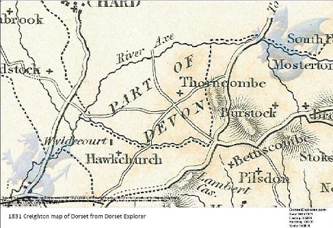
As the 1831 Creighton map above shows, Thorncombe at this time was a Devon parish,
an enclave, part of an isolated part of Devon separated from the main part of Devon
by the Dorset parishes of Hawkchurch and Chardstock. The parish also contained a
detached part of Axminster parish, the tithing of Beerhall and Easthay, lying between
Thorncombe and Hawkchurch and was part of Axminster Hundred. The ecclesiastical
parishes of Thorncombe and Hawkchurch were part of the diocese of Exeter. In Parliamentary
elections the few residents entitled to vote would elect one of the two Knights of
the Shire for Devon.
The process of Thorncombe’s incorporation into Dorset began with the Great Reform
Act of 1832. It made changes to parliamentary constituencies and the voting system.
Thorncombe Parish and part of Axminster Parish “namely Burhall Downs [Beerhall] and
Easthay” were transferred from the Devon to the Dorset electoral district. Stockland
parish and Dalwood Township were transferred from the Dorset to the Devon electoral
district. Changes to the Parliamentary Boundaries in 1832 were quickly echoed by
a change to the Ecclesiastical boundaries for these parishes. An Order in Council
of the 5th October 1836 transferred Thorncombe Parish from the Diocese of Exeter
to the Diocese of Salisbury. In 1844 The Counties (Detached Parts) Act was passed
which ‘annexed detached parts of Counties to the Counties in which they are situate’.
As a result, Thorncombe and the detached part of Axminster both became part of Uggscombe
Hundred.
Other administrative units were subsequently formed which retained the parish’s
links with Devon. Thorncombe, Hawkchurch and Chardstock became part of the Axminster
Poor Law Union in 1836, and subsequently part of the Axminster Registration District.
With the creation of Sanitary Districts as a result of the 1875 Public Health Act,
the three parishes also became part of the Axminster Rural Sanitary District. The
1894 Local Government Act created Urban and Rural District Councils. Existing Urban
and Rural Sanitary Districts were abolished under the legislation. Thorncombe remained
in Dorset, and instead of becoming part of Axminster Rural District became part of
Beaminster Rural District. The Local Government Act of 1972 abolished Rural and
Urban District Councils. As a result, Beaminster Rural District was amalgamated
into West Dorset District Council on 1st April 1974.
Somerset
Other changes to Thorncombe’s boundaries took place in 1966. The Hancock Commission
was set up under the 1958 Local Government Act. Among proposals considered was the
transfer to Dorset of the ‘part of the Chard parish of Wayford south of the River
Axe’ and the transfer to Somerset of ‘that part of Thorncombe lying between the former
and present line of the River Axe’. Somerset suggested instead the transfer of a
larger area of Thorncombe including an industrial area known as ‘Yonder Hill’ just
to the south of the River Axe close to Chard Junction. This suggestion was accepted
by the Commission, and the suggestion was adopted. The proposal came into effect
on 1st April 1966, establishing Thorncombe’s current parish boundaries.
This is an edited and abridged version made by Eve Higgs in April 2013, of a booklet
on Thorncombe boundaries, 'Thorncombe - A Tale of Three Counties' by J W Hart by
kind permission of the author. The booklet includes a detailed explanation of the
boundary changes from 1832 onwards with maps relating to Thorncombe, the county boundaries
and the surrounding parishes. A printable version of the whole booklet in A5 PDF
format is available here.


