


THORNCOMBE’S MARKET
As part of his research for Magna Brittania , published in 1822, Samuel Lysons sent out questionnaires to parishes the length and breadth of the land. Thorncombe’s entry is in Volume VI, covering Devon 1 . The parish became part of Dorset in 1844 following parliamentary boundary changes. The following letter from Charles Egerton, Vicar of Thorncombe dated 11 January 1821, was recently found among Lysons Notebooks in the British Library 2 . Egerton is writing in reply to a further inquiry from Lysons describes Thorncombe’s defunct Saturday market.
‘ I have delayed answering your letter of the 31st in [hope] of finding somebody
who could recollect the exact period at which the Market House at Thorncombe was
pulled down but what is very extraordinary that [sic] I find many who perfectly
remember it, none can at all recollect the time of its removal. They account for
their large [forgetfulness] upon this point by saying that after a gradual [declination]
of the market, it entirely stopped for some time & then again was revived for a short
time, & again ceasing the buildings were at last pulled down. They state that there
was a very pretty market place for grain and meat, & had [some] little shops [permanent
stalls] for other wants, & that it was enclosed with a wall and folding gates –
that it stood on the north side of the road a little away from it at the higher
extremity of the village and that now forms part of a larger field called Pinneys
Close. From putting together the various information I have received I am induced
to [infer] that the date of its destruction was about 50 years ago, since which time
there has not been even a nominal market day.’ 
The Terrace, 1-
Location
Cross referencing Egerton’s description with the 1840 Tithe Map 3 and the 1838
apportionment 4, locates the market house as standing on the site of ‘Great
Pinney’s Close’ on which 1-
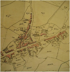
Detail from 1840 Assize copy of Thorncombe Parish Tithe Map, held at Devon Records Office,
showing the centre of Thorncombe village. Plot 956 is the site of the 18th century weekly market.
Despite Thorncombe’s market charter dating back to 1313 5, the earliest documentary evidence of regular weekly markets being held in Thorncombe discovered to date, is another questionnaire dated 1767. It was completed by Thorncombe’s Reverend Samuel Hood for Jeremiah Milles, the Dean of Exeter who investigated Devon’s agriculture. The results were never published but a rather poor quality microfiche of the manuscript held in the Bodlieian can be examined in the West Country Studies Library 6. Pulman apparently got his information about Thorncombe from antiquarians such as Risdon and Polwhele 7,8,9. In his 1854 Book of the Axe he dates the closure of Thorncombe market as 1773 ‘or thereabouts’, which he probably lifted from Lysons’s notebooks who in his turn drew from Exeter antiquarian William Chapple’s unpublished notebooks, now apparently lost.
Turnpikes and Cattle Disease
Two factors, turnpiking and cattle disease have been identified as being instrumental in the market’s eventual closure. In 1770 or thereabouts, the coach road to Thorncombe from Hawkchurch Common to Venn, via Easthay, Schoolhouse and the High Street was turnpiked by the Lyme Regis Trust together with the road to Crewkerne through Birdsmoorgate and a toll house was installed at Thorncombe Thorn 10,11. Passersby today may spot the slightly lower window facing Horseshoe Road. This is where the toll house keeper sat to collect the tolls.
By now the main road linking Axminster and Chard and onwards to Crewkerne were also turnpiked by the Yeovil Trust, ring fencing the Synderford Valley. Each trust charged for the use of their improved roads. The network of footpaths and tracks surrounding Thorncombe and diverging in the vicinity of High Street/Chard Street enabled local traders and punters to avoid Thorncombe’s toll house. But those from further afield had to pay up to two tolls in order to visit the market which made Thorncombe’s Saturday market an expensive day out. Traders and punters alike must have eventually simply stopped coming and taken their custom to neighbouring markets in Axminster, Crewkerne and Chard, undermining the market’s viability.
Added to which, during the second half of the eighteenth century, several outbreaks of cattle disease resulted in national restrictions on cattle movements 12. This may account for older Thorncombe residents recalling in 1821, that the market closed down then starting up again. An act of parliament, passed in 1772 ‘to prevent the further spreading of contagious Disorder in horned cattle’ probably tolled Thorncombe market’s final death knell around 1773.
References
1. Lysons, S. (1822) Magna Britannia: Volume 6 Devonshire , pp. 496-
(on-
2. BL Add. MSS. 9427, p. 116
3. DRO Thorncombe Parish Tithe Map 1840
4. DHC PC/THO Thorncombe Parish Tithe Map Apportionment 1839
5. Maxwell, H.C. et al (1908), Calendar of the Charter Rollspreserved in the Public
Record Office Vol. 3, London, HMSO p. 240 (on-
6. Milles, Jeremiah, (1767-
7. Risdon, T. (1811) The chorological description of Survey of the county of Devon [1640], London, Rees and Curtis
(on line at www.google.co.uk/books accessed 25.11.2012)
8. Polwhele, R. (1997), The history of Devonshire [1793] Intro by A.L. Rowse,
Dorking, Kohler & Coombes, pp. 285-
9. Pulman, G. (1844), Book of the Axe, p. 212
(on-
10. 31 Geo.II c. 43, (1757) p.8
11. 10 Geo.III c.59 (1770) pp.124-
12. Spinage, C., (2003) Cattle Plague: a history, New York, Springer
(on-
Abbreviations
BL: British Library
DHC: Dorset History Centre
DRO: Devon Records Office
WCSL: West Country Studies Librar
© EVE HIGGS
November 2012
| Membership |
| History of the Trust |
| Committee |
| Constitution of the Trust |
| Minutes of meetings |
| Archived Minutes |
| Contacts |
| Newsletter |
| Past Events |
| 20th Anniversary |
| Clapton Mill tour |
| Rock pool search |
| Photo exhibition |
| Nature Diary |
| Trees |
| Commemorative Trees |
| Johnson's Wood |
| Plants and Flowers |
| Geology and geography |
| Wildlife |
| Birds |
| Chard Junction Nature Reserve |
| Nature Reserve pictures |
| Butterflies |
| Butterfly survey |
| Photo albums |
| Artists and writers |
| Footpaths |
| General |
| Poor relief |
| Houses |
| In the news |
| Industry |
| Pubs |
| Religion |
| Reminiscences |
| Schools |
| 17th and 18th centuries |
| Harry Banks |
| Pissarro |
| Hedge Dating |
| Once upon a Thorncombe Road |
| Thorncombe's History |
| The poor |
| Workhouse |
| Chard St Bakery & Forge |
| Holway Cottage |
| Forde Abbey |
| Gough's Barton |
| Holditch Court |
| Upperfold House |
| Sadborow Hall |
| Wayside |
| Dodgy local ice-cream |
| Gribb arsenic poisoning |
| Industrial relics |
| Westford Mill |
| Broomstick Weddings |
| Royal Oak |
| Golden House |
| St Mary's Church |
| Thorncombe's Chapels |
| Quakers |
| Commonwealth vicars |
| Who was William Bragge? |
| Hewood |
| Donald Hutchings school |
| Donald Hutchings wartime |
| Louise May Silver |
| Starting out in 1960s Thorncombe |
| Village Life in the 1980's |
| Wilfred Potter |
| Holditch memories |
| St Mary's School |
| Forgotten epidemic |
| Jacobites |
| Thorncombe Market |
| Walk 1 |
| Walk 2 |
| Walk 3 |
| Walk 4 |
| Walk 5 |
| Walk 6 |
| Walk 7 |
| Rights of Way information |
| Membership |
| History of the Trust |
| Committee |
| Constitution of the Trust |
| Minutes of meetings |
| Contacts |
| Newsletter |
| Past Events |
| 20th Anniversary |
| Clapton Mill tour |
| Rock pool search |
| Photo exhibition |
| Trees |
| Commemorative Trees |
| Johnson's Wood |
| Plants and Flowers |
| Geology and geography |
| Wildlife |
| Chard Junction Nature Reserve |
| Nature Reserve pictures |
| Butterflies |
| Butterfly survey |
| Artists and writers |
| Footpaths |
| General |
| Poor relief |
| Houses |
| In the news |
| Industry |
| Pubs |
| Religion |
| Reminiscences |
| Schools |
| 17th and 18th centuries |
| Harry Banks |
| Pissarro |
| Hedge Dating |
| Once upon a Thorncombe Road |
| Thorncombe's History |
| The poor |
| Workhouse |
| Chard St Bakery & Forge |
| Holway Cottage |
| Forde Abbey |
| Gough's Barton |
| Holditch Court |
| Upperfold House |
| Sadborow Hall |
| Wayside |
| Dodgy local ice-cream |
| Gribb arsenic poisoning |
| Industrial relics |
| Westford Mill |
| Broomstick Weddings |
| Royal Oak |
| Golden House |
| St Mary's Church |
| Thorncombe's Chapels |
| Quakers |
| Commonwealth vicars |
| Who was William Bragge? |
| Hewood |
| Louise May Silver |
| Starting out in 1960s Thorncombe |
| Village Life in the 1980's |
| Wilfred Potter |
| Holditch memories |
| St Mary's School |
| Forgotten epidemic |
| Jacobites |
| Thorncombe Market |
| Walk 1 |
| Walk 2 |
| Walk 3 |
| Walk 4 |
| Walk 5 |
| Walk 6 |
| Walk 7 |
| Rights of Way information |